
![]()

|
The
UK Chapter of the Eurographics Association
(EGUK) presents:-
|
|
|
Theory
and Practice of Computer Graphics 2005
|
|
|
University of Kent, Canterbury, UK |
15th
to 17th June 2005 |
Conference
Easy for printing and travelling around with is this pdf version of our Campus guide including our maps and directions for travel.
Location maps
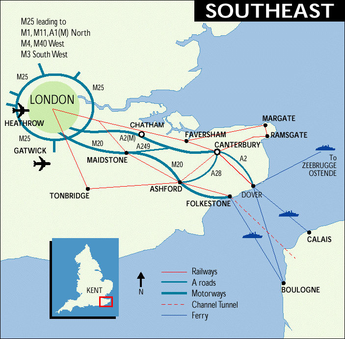
The County of Kent is situated in the South East of England. The University sits on a hill over-looking the City of Canterbury and its world renowned Cathedral.
Please click on an image for an enlarged version:
|
SOUTHEAST |
CANTERBURY |
|
|
|
Directions for travel
By sea and rail from:
- Calais to Dover - approx. 75 minutes by ferry, one hour by Seacat.
- Ostend to Dover - two hours by Seacat. Direct trains from Dover Priory to Canterbury East every half hour on weekdays (hourly on Sundays). Journey time approx. 30 minutes.
By air to:
- Kent International Airport
(Manston); Taxi to the University, or Euro Shuttle Coach to Canterbury
West.
(This is the closest airport to the University).
EUJET.com are the main operator and they run cheap flights to many destinations.
- London Airport (Heathrow); Underground to Victoria Railway Station, train to Canterbury East.
- London Gatwick;
Gatwick Express to Victoria, train to Canterbury East.
From Canterbury West or Canterbury East Stations either take a taxi to the University of Kent, or take a bus, see below.
The Channel Tunnel
- From France and Belgium take the Eurostar to Ashford - journey time approx 2 hours Paris, 1 hour 40 minutes Brussels, 1 hour Lille; regular train services from Ashford to Canterbury West - approx 30 minutes journey time.
- From France (by road/rail) take Le Shuttle from Calais to the Folkestone Eurotunnel Terminal. From the terminal, follow signs to Folkestone, Dover, Canterbury and Ramsgate (M20/A20). Stay on the A20 until instructed to join the A260 signposted Canterbury - approx 40 minutes journey time.
By rail from:
- London (Victoria) to Canterbury East: Journey time approx. 85 minutes. Mondays to Saturdays two trains an hour (one direct, one change at Faversham). Sundays - direct hourly service.
- London (Charing Cross
or Waterloo East) to Canterbury West: Journey time approx. 90 minutes.
Monday to Friday - direct hourly service through most of the
day.
Taxis are available at both Canterbury stations.
Further information available from South East Trains
By road from:
- London: M2, A2 (56 miles; 89km)
- Dover: A2 (16 miles; 26km)
- Folkestone (Tunnel Terminal): M20/A20, A260, A2 (23 miles; 36km)
- Ramsgate: A253, A28 (18 miles; 29km)
- Ashford: A28 (14 miles; 22km)
- Maidstone: (26 miles; 42km) and
- Tonbridge (40 miles; 64km): M20, M2, A2
- From the North or West:
M25, M20, M2, A2
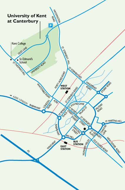
Canterbury to the University: Canterbury central ring road, A290 Whitstable Road, St Thomas Hill, approx. 1 mile (1.6km) along the A290, University entrance on right (signposted) near top of hill.
The visitors' car park on Giles Lane is a `Pay and Display' car park. Parking elsewhere is very restricted and for permit holders only.
By bus:
- Canterbury Bus Station to the University. Regular bus service, taking approx. 14 minutes. (See map for bus stops on campus.)
- From Canterbury East either follow path on City Walls to Bus Station (clearly visible by City Wall), or turn right out of station (pass nightclub) turn corner slightly down hill for bus stop on the ring road.
- From Canterbury West
turn right out of station, walk to main road, bus stop is on far side,
approx. 50 metres to left
Further information available from Stagecoach in East Kent